
What the Governor Wants, He Gets?

The proposed location of Sites Reservoir. Credit: Sue Graue.
Governors Brown and Newsom have made no secret of their strong support for the construction of another west-side off-stream reservoir to park Sacramento River water. Such a giant reservoir would exist in the seismically prone valleys of the Coast Range west of the Central Valley.
Unlike the 2-million acre-foot B.F. Sisk (San Luis) Dam west of Los Banos that takes water from the Sacramento/San Joaquin River Delta (also proposed for an expansion), the proposed 1.5 million-acre Sites dam would slurp up Sacramento River upstream in the north state.
Governor Brown was no stranger to this project. In 1980, the young Governor Brown signed SB 200, the Peripheral Canal bill that would have contingently authorized the Sites dam and reservoir project. (California voters rejected SB 200 in a statewide ballot referendum in 1982.)
After Sites was gifted an allocation of almost $900 million in state taxpayer funds (made available by a statewide ballot measure supported by Brown), Governor Newsom called for regulatory streamlining for needed approvals for the project, one of many disappointments from his Administration. This year, the legislature handed him a streamlined California Environmental Water Quality Act litigation path (in the event of legal challenges to the project’s final environmental impact report).
The State Water Resources Control Board (Water Board) is no political novice. It has quickly started the process of assigning a state water right to the project with the announcement that the Administrative Hearings Office is starting up the wheels of the Water Board.
Friends of the River and some other environmental groups are parties to this upcoming Water Board proceeding. With the near panic by many of the state’s powerful southern California water districts induced by the recent California and Colorado River droughts, the pressure will be on to sacrifice more of the Sacramento River. So, hold on. It could be a rough ride.
More of What the Governor Wants
WRITTEN BY RON STORK
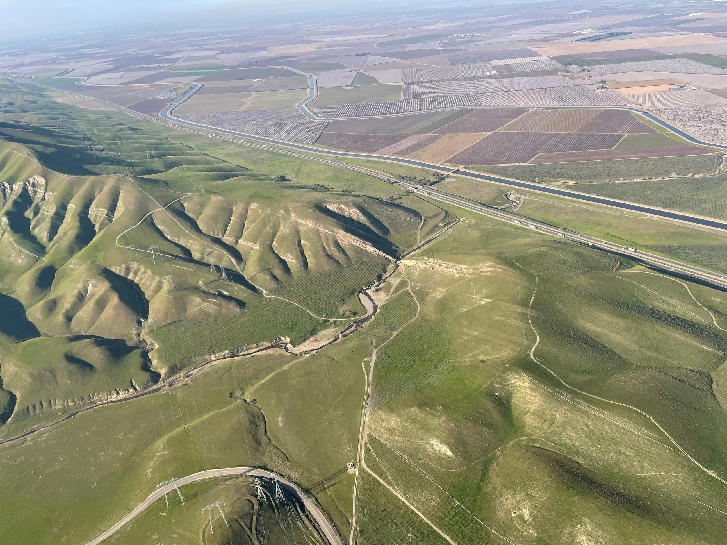
An aerial view of Del Puerto, the geologic feature that creates the “gateway” of Del Puerto Canyon. The land in the foreground would be flooded by Del Puerto Reservoir, and the gateway destroyed. In the background one can see I-5 and almond orchards in bloom. FOR Archives.
Yes, Coast Range Central Valley west-side dams seem to be all the rage. Not to be outdone, the little Del Puerto Water District didn’t have to look far to find canyon to dam. And, it’s practically named after them (well, the reverse, actually).
The canyon is the Del Puerto Canyon, just west of Patterson near I‑5. For just $750 million (and the sacrifice of some private rangeland, the canyon, and its noteworthy portal formation from which it receives its Spanish appellation) the water district will gain water storage for its ~21,000 acres of almonds, and ~12,000 acres of other crops. It’s just an 82,000 acre-foot reservoir to be filled with the District’s and the San Joaquin River exchange contractors’ Central Valley Project taxpayer-subsidized water… since there are apparently not enough reservoir bathtubs in California.
Of course, the proposed dam received support from Governor Newsom just in time to be eligible for up to a 25% federal taxpayer subsidy under Senator Dianne Feinstein’s semi-expiring 2016 “drought” bill, the Water Infrastructure Improvements for the Nation Act (WIIN). Not to be outdone, albeit on a divided vote, the California Water Commission piled on and let the District preserve its potential eligibility to receive the 2014 Proposition 1 California Water Bond state taxpayer subsidies for the project.
Of course the project has brought some opposition, Friends of the River joined in a lawsuit on the project’s environmental impact report, but recently the canyon area and its surrounding heights have reminded us that there are geologic and biological realities there, although not a needed reminder for some of us. First was the recognition that California condors used to use the area — and are now returning.
Then the earth itself reminds us that the California coast range has been shaped and fractured by millions of years of the earth’s tectonic action. Yes, that means earthquakes — on faults mapped and unmapped alike. Just west of Patterson, too.
Next up, sometime this month the U.S. Bureau of Reclamation releases its environmental impact statement, another opportunity to provide a potential dam funder information and perspectives about one more proposed dam in California.